operational discharge and flooding predictions in head catchments
|
|
OPAQUE - |
Operationelle Abfluss- und Hochwasservorhersage in
Quellgebieten operational discharge and flooding predictions in head catchments |
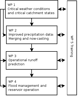
This work package deals with three main topics:
Current weather forecasts shall be refined for flood forecasting by means of statistical models. These models are calibrated using observations of atmospheric conditions (reanalyses), on the one hand, and local weather records (representing the catchment) on the other. The models are adapted to flood-relevant weather conditions. Both deterministic as well as probabilistic weather forecasts shall be considered. The first to identify particularly critical atmospheric circulation types, the latter to obtain an early warning system based on probabilities. The deterministic forecasts are derived from the global forecast model, GME, of the DWD, and probabilistic forecasts from the ensemble prediction system, EPS, of the ECMWF. Of these models, we seek to use those fields that optimally combine predictability and hydrologic relevance, such as pressure and moisture fields.
The statistical models, which are based on weather types and on regression, respectively, have been successfully applied in climate impact research for the provision of precipitation scenarios. For OPAQUE, they will be adapted to the special needs of weather forecasts.
The use of numerical and empirical models thus combines the predictive power of dynamics with the accuracy of long observational records. It is expected to provide a prototype early warning system of heavy rainfall in the range of approximately 3 - 5 days, and thus exceeds the accuracy and reliability of conventional weather forecasts.
For soil moisture, a suitable observation net for the spatial distribution of soil moisture was set-up with innovative spatial TDR technology measurements, with geo-radar as well as microwave information taken from airplane and satellite. A further goal is the determination of a filter function, which allows a reliable esti- mation of soil moisture in the models LARSIM and NASIM on basis of the observed moisture.
With respect to snow cover a network of ground stations for the measurement of snow thickness and snow moisture is to be developed. Pressure sensors, so-called snow pillows as well as snow moisture measurement cables are used. The data from the distributed, ground-based snow measuring net are geo-statistically combined with procedure for the satellite-based estimation of the spatial expansion of the snow cover, developed in the context of In-Ferno project. Additionally a spatially distributed snow model is used for the description of the energy balance and the temperature and water regime of the snow cover.
Last updated Sept 17 2007. Contact Information